mrflib Am I pretty much stuffed here (see 360 image in prev. post).
Don't give up yet :-) Drift alignment is such a pain that I don't wish it on anyone.
We all started with just polar scopes. I thought Drift Alignment was a god send when drift alignment became available in PHD2 since you no longer have to strain your neck with the polar scopes. Problem is that you just became mosquito food with a bright laptop outdoors. When PoleMaster came out, I thought that was another god send, but was really irritated that it was using the human as the plate solving tool (matching the pole masters 5-star asterism). And that was when SharpCap came around. It was a perfect solution when they got greedy and went to a subscription model, and I dropped them (as I do with PhotoShop, etc) like a hot potato. That was when ASIAIR implemented a similar method.
All of these methods require some view near (or on top of) the North Celestial Pole (or SCP). Except for polar scopes, none of them explicitly requires Polaris, since Polaris is not located at the pole. What they do is to depend on the fact that if you move just one axis of the mount and leave the other axis absolutely fixed, then with two measurements, you can accurately triangulate the location of your mount's polar axis amount the stars. After that, it is just a matter of adjusting the mount so that it points close to the actual pole (plate solving, or human pattern matching in the case of the PoleMaster).
Depending on how long your exposures are, you do not need very accurate polar alignment. The unwashed will try to adjust to better than 10 arc seconds (and not knowing that that is the accuracy limit of ASIAIR anyway; so a 0 arc second error may actually be a larger error than a 10 arc second error).
Once you autoguide, the mount will track a guide star, and the rest of the frame will field rotate around that guide star (not around the center of the frame). With multistar guiding, the field will rotate, in the case of ASIAIR around the SNR weighted centroid of all the guide stars.
With today's CMOS sensors and the sky background you do not need more than 120 to 180 seconds of exposure before the sky background has integrated above the noise of the camera and dim DSO objects have already reached as much SNR as you can squeeze out of the sky noise.
(Since you have trees and backyard, you are probably not out in the field where it is Bortle 1, nor in the middle of NYC with Bortle 9, so I am guessing Bortle 5 to 8). You can experiment by taking different exposures, and once the average ADU of a star field is some factor of 3 to 10 above the min ADU, you pretty much don't need to expose for longer.
The length of exposure will determine the polar alignment accuracy. There are web calculators that let you calculate the amount of field rotation, but I suspect that if you are using a OTA with a focal length in the neighborhood of 600mm, that even 5 arc minutes of polar alignment accuracy is not a problem.
So, we only need to get you to 1/10 of a degree type of accuracy.
The interesting thing is that you can get altitude angles to within 0.1 degrees with a moderately cheap digital inclinometer
https://www.amazon.com/gp/product/B077T7XW7X
(I also have a couple of others that are half as accurate and half the price at Amazon, and they might be good enough too. You do have to be careful about calibration with all of them, since resolution does not equal accuracy.)
Knowing your latitude accurately, you can then use one of these gizmo to adjust the elevation of your mount's polar axis.
Compass direction is infinitely harder to measure to 0.1 degrees (I am sure the Navy and Air Force knows how, but us peons will need ready made tools.)
The tool we have is the heavens.
Notice that on the celestial sphere, if your polar alignment is correct, then if you move the declination axis (remember, do not even touch the RA axis of the mount), the RA will remain absolutely constant (remember to turn on mount tracking).
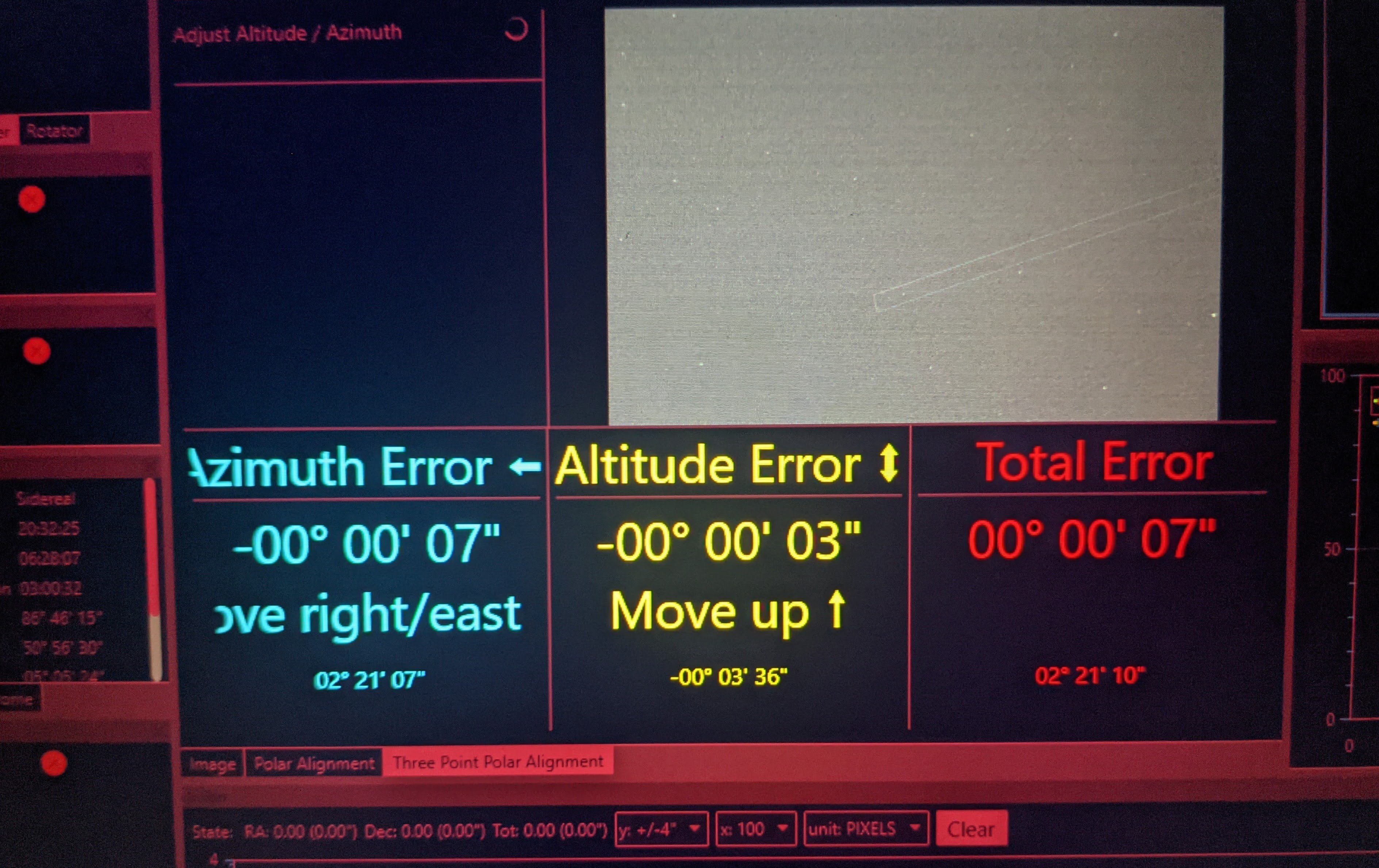
Aha, your ASIAIR comes with a plate solving tool!
So, to get the azimuth adjusted, take a plate near the meridian (say within an hour of the meridian);note down the RA of the plate center. Now slew the declination for some 60º to 90º. (do not use GOTO, use the slew buttons). The longer the distance, the more the error in RA will show up.
When you do that, you will notice that the two RA are different.
Adjust your azimuth bolts, do another plate solve and try to adjust so that the error is about half or less than what you first saw.
Once you have that, note the RA accurately and now slew the declination back, and check the plate center. Now, adjust the azimuth knob to again try to half the error while plate solving -- this is no different than what people using the ASIAIR plate solving to polar alignment -- it is a series of steps of rinse and repeat.
Each time you are have reduced the RA error, slew in Declination. Keep doing until you are within 0.1º or whatever you consider satisfactory.
Interestingly, looking at the celestial sphere, you can actually use the same scheme, rocking the RA back and forth while keeping the declination axis constant near the equator (for maximum sensitivity -- the constant declination can be any angle) while looking for declination error in the plate solutions.
The problem is that unless your mount is perfectly leveled in North-South and East-West, the altitude adjustment and the azimuth adjustment will affect one another -- and it may take a long time to go back and forth. That is why I recommend using an inclinometer to measure the elevation angle ("altitude") of the polar axis, lock it down, and only apply the rocking to the declination axis to get the axis aligned perfectly in azimuth.
Chen